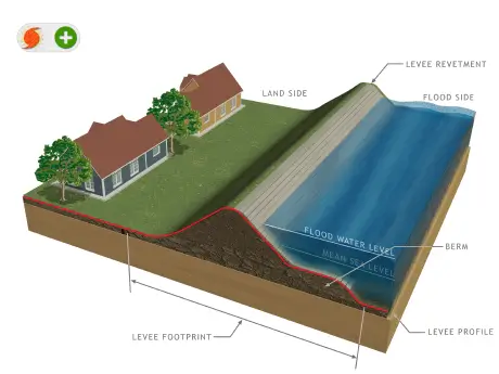
LEVEE BASICS
How Levees Work
Every levee looks a little different in the U.S. – including the materials used to build them, how long, wide, or tall they are, whether they are designed to withstand high water along a river, or wind and waves in a coastal area, and what is nearby and benefitting from the levee being there.
But all levees work the same way – they create a shared line of defense against high water.
Image: Wilkes Barre Terrace and Portal, Wyoming Valley Levee System, photo by Army Corps of Engineers

Levee Characteristics
Basic characteristics of levees and how they work include the following:
-

Typically constructed along a watercourse (not across a watercourse like a dam), such as rivers, tributaries, coastlines, canals, or other waterways.
-
Designed to exclude flooding from a limited range of flood events. Levees do not eliminate the risk of flooding.
-
Usually subjected to flood loading of a limited duration (days or weeks); however, some levees are continuously loaded.
-
Typically comprised either of earthen embankments, concrete floodwalls, or a combination of both.
-
Can have other features such as pedestrian gates, traffic closures, and pump stations.
-
Will usually tie into high ground on either end, but some levees do exist that are open-ended or could form a ring.
-
Could be designed to be compatible with a designed channel or canal.
-
May be linked to or comprised of other structures that are integral to the levee, such as roadways, railroad, or canal embankments.
-
May be linked to dam-related structures and coastal barriers, which can also be integral to a levee or can function like a levee.
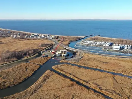
A Closer Look - Levees along Coasts
Levees can be built in coastal areas. When building these levees, it is important to consider the impacts of hurricanes, which bring waves and wind with them. These levees are often designed to withstand wave runup and wind, as well as high water from nearby streams or rivers.
To the right, you’ll see an example of a coastal levee system. In addition to being designed to handle waves and wind, tidal activity and projected sea-level rise are important considerations for levees in coastal areas.
Photo by U.S. Army Corps of Engineers North Atlantic Division
The Port Monmouth Flood Risk Management Project, once complete, will include levees, floodwalls, dunes, and periodic beach renourishment along the Raritan Bay and Sandy Hook Bay in Port Monmouth Middletown Township, Monmouth County, New Jersey. The project is designed to provide protection to low-lying residential and commercial structures, built upon and near salt and freshwater marshes that are experiencing flooding caused by coastal storms.
Photo by Charles Rogers, U.S. Army Corps of Engineers, New York District.
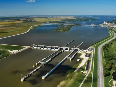
A Closer Look - Levees along Rivers
Levees are commonly built alongside rivers or streams – which can be large or quite small. These levees are typically designed to a certain size and shape to handle possible flooding within a watershed. Multiple levees along a shared waterway can create a line of defense for a broader area.
The Upper Wood Levee is part of a flood risk management system that reduces flooding to nearby counties. The levees also make up part of the containment features for Melvin Price Lock and Dam, which supports navigation on the Mississippi River.
Photo by U.S. Army Corps of Engineers St. Louis District
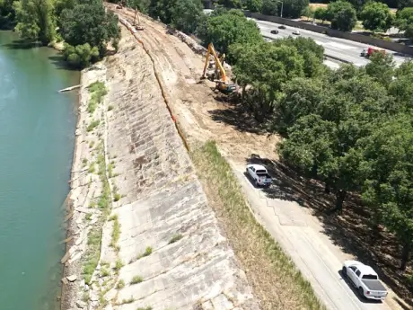
A series of levees along the Sacramento and American Rivers help address flooding in the Sacramento, CA region.
Photo by U.S. Army Corps of Engineers Sacramento District Aviation Section
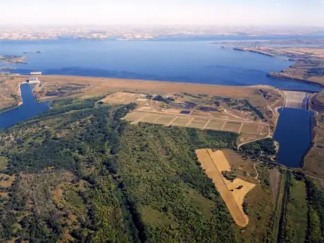
A Closer Look - Levees Associated with a Dam
Levees can also be built to work together with a dam, often to reduce flooding in areas where dams hold water back in a lake or reservoir. When built together, dams and levees can help communities manage flooding within a watershed, as well as locally within a community.
The Williston Levee was designed to reduce the risk of flooding for low lying areas of Williston, North Dakota from backwater effects from Lake Sakakawea, the reservoir for Garrison Dam.
Photo by U.S. Army Corps of Engineers Omaha District
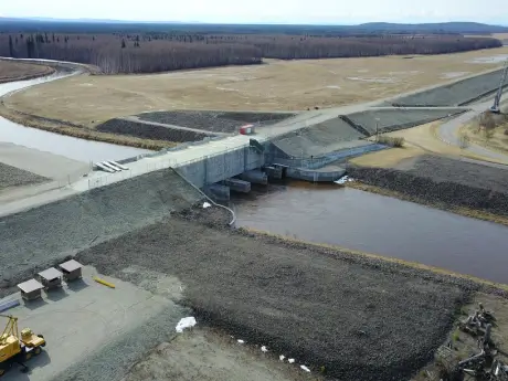
The Chena River Lakes Flood Control Project is designed to reduce flooding to the interior Alaskan city of Fairbanks and will provide residents and visitors a myriad of recreational opportunities on nearly 20,000 acres of public land. The project includes Moose Creek Dam and associated structures such as levees.
Photo by U.S. Army Corps of Engineers Alaska District