


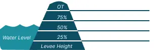
 0 Occurrences
1 Occurrences
3 Occurrences
22 Occurrences
 Vicksburg Protection Works
Location
City, County, and State of the levee system. Determined by the
levee alignment location not the leveed area.
Vicksburg, Warren County, Mississippi
System ID
Unique identifier code for the levee system using 10 or 12 numbers
in length.
5905000032
Operation and Maintenance Organization
Entity responsible for day-to-day management of the levee.
City of Vicksburg
Floodplain Management
Entities responsible for regulating activities that occur in
areas prone to flooding.
FEMA Region 4
Oversight Organization
Entity responsible for oversight of the levee and ensuring it
is maintained.
USACE - Vicksburg District
Last Assesment Date
Last Risk Assessment or Formal Inspection.
3/27/2026
Data Last Updated
Date any of this information for the system has been updated.
9/2/2026
Levee Length
Combine length of all the levee system features including the
embankments, floodwalls, closures where they exist for this
system.
 1.715 Miles
Average Levee Height
The average height of the levee system. The levee profile viewer
on the mapping window will show the actual levee height values
for the length of the levee if available.
 13 Feet
Year Levee Constructed Year levee system was fully completed as a flood reduction
project.
 1956
Summary
General text description of the levee system with a
summary of why the levee is there, and the benefits it
provides.
The Vicksburg Protection works consists of a combination of a concrete floodwall, and an earthen embankment section, located on the east bank of the Yazoo Diversion Canal along the waterfront of the City of Vicksburg, MS. Total length of floodwall is 1.7 miles and total length of levee embankment is .2 miles. The Vicksburg Floodwall is a feature of the comprehensive flood control project of the Lower Mississippi River, authorized by the Flood Control Act of 15 May 28, as amended. The floodwall is a continuous, reinforced concrete wall, consisting of two types of monolithic construction: an I-type wall and T-type or cantilever wall. It was constructed in three reaches, consisting of a main reach, a north extension, and a south extension. Construction on the three reaches began in Jun 52 and was completed in Jan 59. The main reach consists of an I-type wall and a T-type wall. The I-type wall was constructed riverward of the old wall and the space between the two walls filled with sand. The T-type wall replaced the old wall entirely. The north extension contains a 90-degree angle, traverses several railroad tracks and a street to reach a natural hill. The south extension consists of I-type monolithic construction in conjunction with a levee that was part of the old protection system and a short T-type or cantilever monolithic wall section. This new floodwall raises the protection from the elevation of the old floodwall and levee (106.0) to the design elevation of 112.0. The 1973 project design flowline is 111.0 feet. The main reach and the north extension have copper waterstops across the joints and the south extension has rubber waterstops. There are 10 drainage structures that control flows through the wall system. Closure of the remainder of the openings is made by timber stoplogs when needed.
Performance & Condition
General text description of the historical and
anticipated performance of the levee, the people and
property benefitting from the levee and who may be at
risk of flooding, and actions to address areas of
concern.
PLEASE NOTE: The following Risk Characterization is a description of risk associated with this levee system. It may be updated or revised in the future.
The LSOG considers the risk associated with the Vicksburg Protection Works to be Low for both prior to overtopping and overtopping breach scenarios. The levee has an overtopping recurrence of 1/200 ACE with very low life safety risk. The project floodwall has a history of good performance; however, stability analyses indicate performance under full loading is a significant concern. Life loss estimates are very low due to a small population at risk, strong emergency planning and community awareness, and numerous evacuation routes to nearby high ground.
Flooding Hazard
Historic Loading by Percentage of Height
 Representative loading associated with historical
flood information as a percentage of the levee height
or overtopping.
Representative loading associated with historical
flood information as a percentage of the levee height
or overtopping.
0 Occurrences
1 Occurrences
3 Occurrences
22 Occurrences