


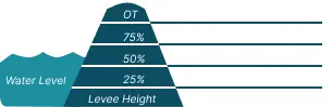
 0 Occurrences
1 Occurrences
3 Occurrences
0 Occurrences
0 Occurrences
1 Occurrences
3 Occurrences
 Long Prairie AR
 Location
City, County, and State of the levee system. Determined by the
levee alignment location not the leveed area.
Bradley, Lafayette County, Arkansas
System ID
Unique identifier code for the levee system using 10 or 12 numbers
in length.
5905000026
Operation and Maintenance Organization
Entity responsible for day-to-day management of the levee.
North Bossier Levee DistrictLong Prairie Levee District
Floodplain Management
Entities responsible for regulating activities that occur in
areas prone to flooding.
FEMA Region 6
Oversight Organization
Entity responsible for oversight of the levee and ensuring it
is maintained.
USACE - Vicksburg District
Last Assesment Date
Last Risk Assessment or Formal Inspection.
11/21/2017
Data Last Updated
Date any of this information for the system has been updated.
8/5/2026
Levee Length
Combine length of all the levee system features including the
embankments, floodwalls, closures where they exist for this
system.
 20.231 Miles
 Average Levee Height
The average height of the levee system. The levee profile viewer
on the mapping window will show the actual levee height values
for the length of the levee if available.
 11 Feet
 Year Levee Constructed Year levee system was fully completed as a flood reduction
project.
 1949
1949 Summary
General text description of the levee system with a
summary of why the levee is there, and the benefits it
provides.
The Long Prairie Levee System is located in southwest Arkansas in Lafayette County and northwest Louisiana in Bossier Parish. The Long Prairie Levee System is comprised of two segments. The upper segment is the Long Prairie Segment and the lower portion is the North Bossier Levee Segment in Bossier Parish, LA. The Long Prairie Levee begins in Lafayette County, Arkansas and ends at the Louisiana State line. The North Bossier Levee Segment begins at the Louisiana State Line and extends south to high ground. These levees are part of the Red River Below Denison Dam Levee Project in which the local sponsors have major and minor maintenance responsibility. The Long Prairie Levee Segment is 17 miles of earthen levee and the North Bossier Levee Segment is 3 miles of earthen levee. The Long Prairie Levee District is the sponsor for the Long Prairie segment. The North Bossier Levee Segment does not currently have a sponsor. This segment has had no maintenance since the early 1990’s and there is no schedule for repairs. The Flood Control Act of 24 July 1946 authorized the construction of this flood control structure. The levee provides risk reduction to approximately 700 people and $43,200,000 of property value.
Performance & Condition
General text description of the historical and
anticipated performance of the levee, the people and
property benefitting from the levee and who may be at
risk of flooding, and actions to address areas of
concern.
PLEASE NOTE: The following Risk Characterization is a description of risk associated with this levee system. It may be updated or revised in the future.
The LSOG considers the risk associated with the Red River Levee LB – North Bossier levee to be Low. The levee has experience a maximum load of approximately 54%. The potential for poor performance is driven by embankment seepage due to composition of the embankment (silty and sandy clays), excessive unwanted vegetation that has impeded an effective inspection and lack of an active sponsor. In addition, there is uncertainty in performance for embankment stability and embankment erosion. The majority of the population at risk is located in depths of flooding less than 6 feet and generally located in the northern portion of the leveed area. The evacuation effectiveness is acceptable, routes of egress are relatively short.
Flooding Hazard
Historic Loading by Percentage of Height
 Representative loading associated with historical
flood information as a percentage of the levee height
or overtopping.
Representative loading associated with historical
flood information as a percentage of the levee height
or overtopping.
Representative loading associated with historical
flood information as a percentage of the levee height
or overtopping.
0 Occurrences
0 Occurrences
1 Occurrences
3 Occurrences