


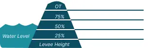
 0 Occurrences
10 Occurrences
21 Occurrences
 Lake Creek
Location
City, County, and State of the levee system. Determined by the
levee alignment location not the leveed area.
Troy, Lincoln County, Montana
System ID
Unique identifier code for the levee system using 10 or 12 numbers
in length.
5505000325
Operation and Maintenance Organization
Entity responsible for day-to-day management of the levee.
Lincoln County, MT
Floodplain Management
Entities responsible for regulating activities that occur in
areas prone to flooding.
FEMA Region 8
Last Assesment Date
Last Risk Assessment or Formal Inspection.
9/20/2021
Data Last Updated
Date any of this information for the system has been updated.
10/24/2024
Levee Length
Combine length of all the levee system features including the
embankments, floodwalls, closures where they exist for this
system.
 0.083 Miles
Average Levee Height
The average height of the levee system. The levee profile viewer
on the mapping window will show the actual levee height values
for the length of the levee if available.
 No Data
Year Levee Constructed Year levee system was fully completed as a flood reduction
project.
 1916
Summary
General text description of the levee system with a
summary of why the levee is there, and the benefits it
provides.
The Lake Creek Levee is a non-federally constructed and non-federally operated and maintained flood risk reduction project sponsored by Lincoln County, MT. This earthen embankment levee is located on the right bank of Keeler Creek about 2500 feet upstream of its confluence with Lake Creek, which then empties into the Kootenai River near Troy, MT. The levee is about 515 feet long. It ties into natural riverbank upstream and ties into a bridge abutment and Lower Lake Creek Road at the downstream end.
Performance & Condition
General text description of the historical and
anticipated performance of the levee, the people and
property benefitting from the levee and who may be at
risk of flooding, and actions to address areas of
concern.
No Data
Flooding Hazard
Historic Loading by Percentage of Height
 Representative loading associated with historical
flood information as a percentage of the levee height
or overtopping.
Representative loading associated with historical
flood information as a percentage of the levee height
or overtopping.
0 Occurrences
0 Occurrences
10 Occurrences
21 Occurrences