


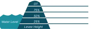
 0 Occurrences
1 Occurrences
1 Occurrences
1 Occurrences
 Sioux Falls - Big Sioux RB
Location
City, County, and State of the levee system. Determined by the
levee alignment location not the leveed area.
Sioux Falls, Minnehaha County, South Dakota
System ID
Unique identifier code for the levee system using 10 or 12 numbers
in length.
4705000109
Operation and Maintenance Organization
Entity responsible for day-to-day management of the levee.
City of Sioux Falls
Floodplain Management
Entities responsible for regulating activities that occur in
areas prone to flooding.
FEMA Region 8
Oversight Organization
Entity responsible for oversight of the levee and ensuring it
is maintained.
USACE - Omaha District
Last Assesment Date
Last Risk Assessment or Formal Inspection.
10/27/2016
Levee Length
Combine length of all the levee system features including the
embankments, floodwalls, closures where they exist for this
system.
 1.592 Miles
Average Levee Height
The average height of the levee system. The levee profile viewer
on the mapping window will show the actual levee height values
for the length of the levee if available.
 9 Feet
Year Levee Constructed Year levee system was fully completed as a flood reduction
project.
 1961
Summary
General text description of the levee system with a
summary of why the levee is there, and the benefits it
provides.
The project is one segment of the larger 8 System Flood Risk Reduction Project in the City of Sioux Falls, South Dakota. The levee embankment starts upstream of the diversion channel chute near Falls Park Road and continues downstream where it ties into high ground east of Cliff Avenue. The total length of the levee is 1.6 miles, and the average height is 12 feet. The levee crown width is generally 10 feet, with side slopes of 1 foot vertical on 3 feet horizontal (1V:3H) on the land side and river side. The project contains 13 gravity drainage structures to convey interior drainage. The project was authorized by the 1954 Flood Control Act. Construction of the project was completed in 1961, and was turned over to the City of Sioux Falls for operation and maintenance. Although this levee was not raised as part of the major modifications completed in 2014, it was re-aligned and fortified with new and larger riprap.
Performance & Condition
General text description of the historical and
anticipated performance of the levee, the people and
property benefitting from the levee and who may be at
risk of flooding, and actions to address areas of
concern.
PLEASE NOTE: The following Risk Characterization is a description of risk associated with this levee system. It is currently undergoing review and may be updated in the future.
A risk assessment was performed in 2015, using inspection ratings from a 2013 Annual Inspection. The levee has performed well since construction was completed. The highest recorded flood since construction occurred in 1969 when the levee was loaded to about 70% of the total height. There were no performance issues for this segment noted at that time. The levee provides approximately a 200-year level of protection against overtopping. Evacuation would be a simple process as there are multiple routes to higher ground to the south. The leveed area is a mix of residential, commercial and industrial properties. General flood warning times are measured in days or weeks due to the nature of snow melt as the primary source of flooding. Breach times would be much less, occurring in minutes or hours. The risk associated with this segment is low for both prior to overtopping and with overtopping.
Flooding Hazard
Historic Loading by Percentage of Height
 Representative loading associated with historical
flood information as a percentage of the levee height
or overtopping.
Representative loading associated with historical
flood information as a percentage of the levee height
or overtopping.
0 Occurrences
1 Occurrences
1 Occurrences
1 Occurrences