


 0 Occurrences
1 Occurrences
11 Occurrences
40 Occurrences
 Mississippi River West Bank - Above Old River
Location
City, County, and State of the levee system. Determined by the
levee alignment location not the leveed area.
Simmesport, Concordia Parish, Louisiana
System ID
Unique identifier code for the levee system using 10 or 12 numbers
in length.
4405000515
Operation and Maintenance Organization
Entity responsible for day-to-day management of the levee.
USACE - New Orleans DistrictFifth Louisiana Levee District
Floodplain Management
Entities responsible for regulating activities that occur in
areas prone to flooding.
FEMA Region 6
Oversight Organization
Entity responsible for oversight of the levee and ensuring it
is maintained.
USACE - New Orleans District
Last Assesment Date
Last Risk Assessment or Formal Inspection.
5/3/2018
Data Last Updated
Date any of this information for the system has been updated.
9/21/2022
Levee Length
Combine length of all the levee system features including the
embankments, floodwalls, closures where they exist for this
system.
 17.496 Miles
Average Levee Height
The average height of the levee system. The levee profile viewer
on the mapping window will show the actual levee height values
for the length of the levee if available.
 No Data
Year Levee Constructed Year levee system was fully completed as a flood reduction
project.
 No Data
Summary
General text description of the levee system with a
summary of why the levee is there, and the benefits it
provides.
The Mississippi River West Bank – Above Old River levee system is a federally authorized flood risk reduction system which is located along the west bank of the Mississippi River, extending from Mississippi River Mile 320 at Blackhawk, LA to Mississippi River Mile 303 at Carr Point, LA south of Old River Lock. The system includes 16.75 miles of levee, six structures, and 400 feet of floodwall. The six structures that comprise Old River Control Complex are 1) Old River Closure Structure, 2) Old River Auxiliary Control Structure, 3) Old River Low Sill Control Structure, 4) Old River Overbank Control Structure, 5) Old River Lock, and 6) S.A. Murray Hydroelectric Plant. These areas have an estimated population of 112,000 and total assets valued at $22.3 billion.
Performance & Condition
General text description of the historical and
anticipated performance of the levee, the people and
property benefitting from the levee and who may be at
risk of flooding, and actions to address areas of
concern.
Above Old River Levee System is classified as a Moderate to High risk due to the high consequences associated with the system in combination with the likelihood of overtopping or breach. If overtopped or breached, the Old River to Alexandria leveed area and the downriver Atchafalaya Basin areas would be inundated with up to 2 feet of overland flow. Additionally, if a breach were to occur, water flows in the Mississippi River below Old River Complex would be reduced, resulting in disruptions to navigation, lack of fresh drinking water, and disruptions to oil and gas refineries. Possible structural failure at Old River Complex was determined to be a high risk driver. The Low Sill Structure was damaged during the flood of 1973. Emergency repairs were performed, and the Auxiliary Control Structure was added in 1986 to reduce pressure on the Low Sill Structure. The Old River Complex structures performed well during the 2011 high water event. During high water events, the Old River Complex structures are monitored with daily visual inspections and weekly bathymetric surveys.
Flooding Hazard
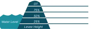
Historic Loading by Percentage of Height
 Representative loading associated with historical
flood information as a percentage of the levee height
or overtopping.
Representative loading associated with historical
flood information as a percentage of the levee height
or overtopping.
0 Occurrences
1 Occurrences
11 Occurrences
40 Occurrences