


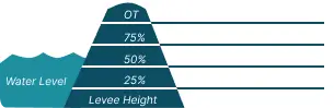
 0 Occurrences
2 Occurrences
28 Occurrences
67 Occurrences
 Mississippi and Ohio Rivers Levee System at Cairo & Vicinity
Location
City, County, and State of the levee system. Determined by the
levee alignment location not the leveed area.
Cairo, Alexander County, Illinois
System ID
Unique identifier code for the levee system using 10 or 12 numbers
in length.
4005000001
Operation and Maintenance Organization
Entity responsible for day-to-day management of the levee.
USACE - Memphis DistrictCity of Cairo, Illinois
Floodplain Management
Entities responsible for regulating activities that occur in
areas prone to flooding.
FEMA Region 5
Oversight Organization
Entity responsible for oversight of the levee and ensuring it
is maintained.
USACE - Memphis District
Last Assesment Date
Last Risk Assessment or Formal Inspection.
9/1/2014
Levee Length
Combine length of all the levee system features including the
embankments, floodwalls, closures where they exist for this
system.
 21.963 Miles
Average Levee Height
The average height of the levee system. The levee profile viewer
on the mapping window will show the actual levee height values
for the length of the levee if available.
 25 Feet
Year Levee Constructed Year levee system was fully completed as a flood reduction
project.
 1950
Summary
General text description of the levee system with a
summary of why the levee is there, and the benefits it
provides.
The Mississippi and Ohio Rivers Levee System at Cairo & Vicinity provides flood risk reduction for approximately 16,521 acres on a peninsula just upstream of the Mississippi and Ohio River confluence. The levee system provides flood risk reduction for the cities of Klondike, Cairo, Mound City, Mounds, IL and other smaller municipalities in the surrounding areas. The leveed area is bounded by the Mississippi River on the west and the Ohio River on the east. The System begins at the northern extreme of the Mound City, IL Levee and Floodwall segment and terminates at high ground north of the Cache River Diversion Channel at the confluence of the Cache River and the Mississippi River. The Levee System consists of 18 miles of earthen levee and 3 miles of floodwall with multiple closures, pump stations, culverts, and diversion channels. The Levee consists of five individual segments.
The levee system is part of the Mississippi River and Tributaries (MR&T) project. The MR&T project was authorized by the 1928 Flood Control Act. In the wake of the devastating 1927 flood, it was deemed necessary to put into place a comprehensive, unified system of public works within the lower Mississippi Valley that would provide unprecedented flood risk management and an equally efficient navigation channel. The MR&T project continues to be one of the world’s most comprehensive and successful flood risk reduction projects.
Performance & Condition
General text description of the historical and
anticipated performance of the levee, the people and
property benefitting from the levee and who may be at
risk of flooding, and actions to address areas of
concern.
The Cairo Levee System has been successful at preventing flooding in the past with considerable flood fights efforts. Several isolated seepage issues were identified during the 2011 flood. The significant investment in underseepage control on this levee since the 2011 flood has decreased but not eliminated the overall risk. The potential exists for flood events higher than 2011 to occur that could lead to overtopping or breach of the levee or floodwall. If that occurred, the developed areas behind the levee would experience very high damages and potential loss of life. Levee sponsors, local communities, and USACE are taking action to reduce risk associated with the levee. However, individual residents and local businesses have roles and responsibilities in reducing their own risk.
Flooding Hazard
Historic Loading by Percentage of Height
 Representative loading associated with historical
flood information as a percentage of the levee height
or overtopping.
Representative loading associated with historical
flood information as a percentage of the levee height
or overtopping.
0 Occurrences
2 Occurrences
28 Occurrences
67 Occurrences