


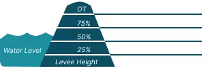
 1 Occurrences
1 Occurrences
2 Occurrences
1 Occurrences
1 Occurrences
1 Occurrences
2 Occurrences
 Armourdale
 Location
City, County, and State of the levee system. Determined by the
levee alignment location not the leveed area.
Kansas City, Wyandotte County, Kansas
System ID
Unique identifier code for the levee system using 10 or 12 numbers
in length.
3605000040
Operation and Maintenance Organization
Entity responsible for day-to-day management of the levee.
Kaw Valley Drainage District
Floodplain Management
Entities responsible for regulating activities that occur in
areas prone to flooding.
FEMA Region 7
Oversight Organization
Entity responsible for oversight of the levee and ensuring it
is maintained.
USACE - Kansas City District
Last Assesment Date
Last Risk Assessment or Formal Inspection.
9/20/2019
Data Last Updated
Date any of this information for the system has been updated.
4/24/2026
Levee Length
Combine length of all the levee system features including the
embankments, floodwalls, closures where they exist for this
system.
 6.278 Miles
 Average Levee Height
The average height of the levee system. The levee profile viewer
on the mapping window will show the actual levee height values
for the length of the levee if available.
 10 Feet
 Year Levee Constructed Year levee system was fully completed as a flood reduction
project.
 1951
1951 Summary
General text description of the levee system with a
summary of why the levee is there, and the benefits it
provides.
The Armourdale levee system reduces the occurrence of flooding to areas of Kansas City, Kansas. The levee system includes 1.3 miles of floodwall and 5.5 miles of earthen levee along the Kansas River. The existing local levee was re-designed and re-constructed by the U.S. Army Corps of Engineers (USACE). Shortly after construction was completed in early 1951 the levee was overtopped and damaged by the 1951 flood. The USACE repaired the damage after the flood and then constructed major improvements that included raising the levee and floodwall in 1974. After construction was completed, the project was turned over to the local sponsor, the Kaw Valley Drainage District, for operation and maintenance. The USACE is currently working on raising the levee and floodwall again.
Performance & Condition
General text description of the historical and
anticipated performance of the levee, the people and
property benefitting from the levee and who may be at
risk of flooding, and actions to address areas of
concern.
The USACE evaluates risk as a combination of the flood hazard frequency, the anticipated levee performance, and the potential consequences. A screening level risk assessment was completed on this levee in 2017. The screening level risk assessment estimated the likelihood of a Kansas River flood overtopping this levee in any given year at approximately 0.2%, or a one chance in 500. Overtopping was identified as the primary flooding risk, however all levees have the potential to breach prior to water flowing over the top. The USACE anticipates there being sufficient warning time to evacuate the area prior to water reaching the top of this levee. However, levee breaches prior to water reaching the top often have very short warning times.
The risk assessment identified some performance concerns prior to water overtopping the levee under large flooding events. With the 2019 Kansas City Levees Project, the USACE is further evaluating these issues and will be constructing improvements as needed, as well as raising the entire project. In 1993, the project was loaded to within a few feet of the top and performed as designed.
The area behind the levee features significant residential and commercial development. The 2017 screening estimated a leveed area daytime population of approximately 6,700 people and a property value of approximately $1.9 Billion.
Flooding Hazard
Historic Loading by Percentage of Height
 Representative loading associated with historical
flood information as a percentage of the levee height
or overtopping.
Representative loading associated with historical
flood information as a percentage of the levee height
or overtopping.
Representative loading associated with historical
flood information as a percentage of the levee height
or overtopping.
1 Occurrences
1 Occurrences
1 Occurrences
2 Occurrences