


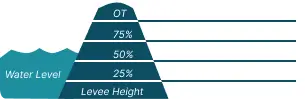
 0 Occurrences
3 Occurrences
10 Occurrences
21 Occurrences
 S-48 North Tieback
Location
City, County, and State of the levee system. Determined by the
levee alignment location not the leveed area.
Palm City, Martin County, Florida
System ID
Unique identifier code for the levee system using 10 or 12 numbers
in length.
3405000121
Operation and Maintenance Organization
Entity responsible for day-to-day management of the levee.
South Florida Water Management District
Floodplain Management
Entities responsible for regulating activities that occur in
areas prone to flooding.
FEMA Region 4
Oversight Organization
Entity responsible for oversight of the levee and ensuring it
is maintained.
USACE - Jacksonville District
Last Assesment Date
Last Risk Assessment or Formal Inspection.
7/31/2018
Levee Length
Combine length of all the levee system features including the
embankments, floodwalls, closures where they exist for this
system.
 1.049 Miles
Average Levee Height
The average height of the levee system. The levee profile viewer
on the mapping window will show the actual levee height values
for the length of the levee if available.
 6 Feet
Year Levee Constructed Year levee system was fully completed as a flood reduction
project.
 1964
Summary
General text description of the levee system with a
summary of why the levee is there, and the benefits it
provides.
The S-48 North Tieback levee system is located in Martin County, Florida west of the city of Stuart. The system was constructed to reduce the occurrence of flooding within the St. Lucie River Basin. The levee is 5 feet high and one mile long, runs along the north side of a drainage canal known as C-23, and ties into a water control structure called S-48. The system was constructed by the U.S. Army Corps of Engineers (USACE) in 1964 and turned over to the South Florida Water Management District (SFWMD) who is responsible for operating and maintaining the levee, canal, and structure. The leveed area includes a residential neighborhood, agriculture, and undeveloped land. Almost 300 people work or live behind the levee, with $16 million in property value.
Performance & Condition
General text description of the historical and
anticipated performance of the levee, the people and
property benefitting from the levee and who may be at
risk of flooding, and actions to address areas of
concern.
The S-48 North Tieback system reduces but does not eliminate the risk of loss of life or economic damages from flood events in the St. Lucie River Basin. USACE risk assessments consider flooding frequency, the likelihood of the levee breaching or overtopping, and the resulting potential loss of lives and damage to homes, businesses, and the environment. Based on the most recent risk assessment of the system in 2018, USACE considers this levee to have a low risk. The most likely threat to the system is seepage due to animal burrows and unwanted vegetation. Seepage is when the water on the flood side of the levee seeps through to the land side. Seepage can carry soil particles with it and if enough soil is moved through the levee, the levee may be weakened and breach. There is no immediate concern the levee will breach. The system is performing as designed. Water would be anticipated to overtop the levee in a storm that has a 1 in 50 chance of occurring in any given year. If the levee breaches or overtops, the range of flooding in portions of the leveed area could be up to 5 feet deep.
Flooding Hazard
Historic Loading by Percentage of Height
 Representative loading associated with historical
flood information as a percentage of the levee height
or overtopping.
Representative loading associated with historical
flood information as a percentage of the levee height
or overtopping.
0 Occurrences
3 Occurrences
10 Occurrences
21 Occurrences