


 0 Occurrences
1 Occurrences
5 Occurrences
9 Occurrences
0 Occurrences
1 Occurrences
5 Occurrences
9 Occurrences
 Texas City Hurricane Flood Protection
 Location
City, County, and State of the levee system. Determined by the
levee alignment location not the leveed area.
Texas City, Galveston County, Texas
System ID
Unique identifier code for the levee system using 10 or 12 numbers
in length.
3105000004
Operation and Maintenance Organization
Entity responsible for day-to-day management of the levee.
Galveston County, TX
Floodplain Management
Entities responsible for regulating activities that occur in
areas prone to flooding.
FEMA Region 6
Oversight Organization
Entity responsible for oversight of the levee and ensuring it
is maintained.
USACE - Galveston District
Last Assesment Date
Last Risk Assessment or Formal Inspection.
4/30/2018
Levee Length
Combine length of all the levee system features including the
embankments, floodwalls, closures where they exist for this
system.
 22.002 Miles
 Average Levee Height
The average height of the levee system. The levee profile viewer
on the mapping window will show the actual levee height values
for the length of the levee if available.
 20 Feet
 Year Levee Constructed Year levee system was fully completed as a flood reduction
project.
 1987
1987 Summary
General text description of the levee system with a
summary of why the levee is there, and the benefits it
provides.
The Texas City and Vicinity Hurricane Flood Protection (HFP) was originally constructed in 1930, and later expanded as part of the federally authorized project between 1962 and 1987. The system is approximately 22 miles long consisting of 20.6 miles of levees and 1.35 miles of flood wall. To secure crossing points for the system there are 18 closure structures in the form of double swing gates, single swing gates, and 1 tide control gate. There are 25 gravity structures and 2 pump stations to assist in removing water from the interior area. The system reduces risk for approximately 45,000 people living and working in the cities of Texas City, La Marque, and the surrounding vicinity. Additionally there is $4 billion in property value of commercial, residential, public property, and $20 billion worth in petrochemical industry within the leveed area of the system. After the completion of construction, the HFP was turned over to Galveston County Judges Office (public sponsor) to be maintained and operated.
Performance & Condition
General text description of the historical and
anticipated performance of the levee, the people and
property benefitting from the levee and who may be at
risk of flooding, and actions to address areas of
concern.
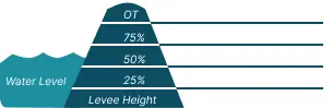
The risk associated with this levee system is considered very high. For the Texas City and Vicinity HFP the record surge loading occurred during Hurricane Ike. The north eastern portion of the system was loaded to 100% of the levee’s height while other sections were only loaded 50% of height. A storm surge larger than what occurred during Hurricane Ike would most likely overtop the levee system. Since Hurricane Ike a section of floodwall has shown signs of movement, and is expected to fail prior to the system being overtopped. Inundation of the area could result in some localized flood depths up to elevation 15 feet. This flooding has a potential for loss of life, and economic damages to critical infrastructure including the internationally significant petrochemical industry.
Flooding Hazard
Historic Loading by Percentage of Height
 Representative loading associated with historical
flood information as a percentage of the levee height
or overtopping.
Representative loading associated with historical
flood information as a percentage of the levee height
or overtopping.
Representative loading associated with historical
flood information as a percentage of the levee height
or overtopping.
0 Occurrences
1 Occurrences
5 Occurrences
9 Occurrences