


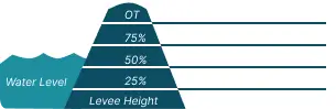
 0 Occurrences
0 Occurrences
4 Occurrences
 East Dallas Levee Trinity LB
Location
City, County, and State of the levee system. Determined by the
levee alignment location not the leveed area.
Dallas, Dallas County, Texas
System ID
Unique identifier code for the levee system using 10 or 12 numbers
in length.
3005000002
Operation and Maintenance Organization
Entity responsible for day-to-day management of the levee.
City of Dallas
Floodplain Management
Entities responsible for regulating activities that occur in
areas prone to flooding.
FEMA Region 6
Oversight Organization
Entity responsible for oversight of the levee and ensuring it
is maintained.
USACE - Fort Worth District
Last Assesment Date
Last Risk Assessment or Formal Inspection.
7/20/2018
Data Last Updated
Date any of this information for the system has been updated.
7/3/2024
Levee Length
Combine length of all the levee system features including the
embankments, floodwalls, closures where they exist for this
system.
 11.832 Miles
Average Levee Height
The average height of the levee system. The levee profile viewer
on the mapping window will show the actual levee height values
for the length of the levee if available.
 No Data
Year Levee Constructed Year levee system was fully completed as a flood reduction
project.
 1959
Summary
General text description of the levee system with a
summary of why the levee is there, and the benefits it
provides.
The Dallas Floodway project consists of a complex system that includes levee embankments, a concrete floodwall, sumps and pumping stations, bridge crossings, conduits, and other penetrations. Only a brief description is included here. More details are described in subsequent sections dealing with potential failure modes and risks. The Dallas Floodway project is located on the Elm Fork, West Fork and Trinity River in Dallas, Texas. The project includes 22.6 miles of levee embankments: 11.7 miles on the northeast levee (usually referred to as the East levee) and 10.9 miles along the southwest levee (generally referred to as the West levee). The East levee protects the Stemmons Corridor (a major transportation route through the City), and parts of Downtown Dallas and the Central Business District from flooding on the Trinity River, while U.S. Army Corps of Engineers Risk Management Center the West levee protects a large portion of West Dallas (largely residential areas). These embankments were originally constructed by the City of Dallas and the Dallas County Levee Improvement District in the 1930’s in response to extreme flooding along the Trinity River in 1908. Originally constructed with 2.5H:1V side slopes, a maximum height of 35 feet and a crest width of 6 feet, the levee system was “strengthened” by USACE in the late 1950s by flattening the side slopes and increasing the crest width to 16 feet in a river-side shift. There are several pump stations on both the East and West Levees. These pump stations have low areas near them where water collects on the land side to be pumped out. These low areas are referred to as “sumps”. The levee embankments are generally comprised of low plasticity clays and high plasticity clays founded on recent alluvial soils. The concrete floodwall is located on the downstream end of the east levee, with a crest elevation generally a few feet lower than the embankment. The alluvial floodplain soils generally consist of alluvial clay deposits, underlain by sandier deposits (becoming coarser with depth), followed by basal sands and gravels. The basal sands and gravels mark the bedrock contact with the Eagle Ford Shale or the Austin Chalk.
Performance & Condition
General text description of the historical and
anticipated performance of the levee, the people and
property benefitting from the levee and who may be at
risk of flooding, and actions to address areas of
concern.
In Progress
Flooding Hazard
Historic Loading by Percentage of Height
 Representative loading associated with historical
flood information as a percentage of the levee height
or overtopping.
Representative loading associated with historical
flood information as a percentage of the levee height
or overtopping.
0 Occurrences
0 Occurrences
0 Occurrences
4 Occurrences