


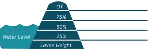
 0 Occurrences
1 Occurrences
1 Occurrences
0 Occurrences
0 Occurrences
1 Occurrences
1 Occurrences
 Levee 37
 Location
City, County, and State of the levee system. Determined by the
levee alignment location not the leveed area.
Mount Prospect, Cook County, Illinois
System ID
Unique identifier code for the levee system using 10 or 12 numbers
in length.
2605000008
Operation and Maintenance Organization
Entity responsible for day-to-day management of the levee.
Illinois Department of TransportationIllinois Department of Natural Resources
Floodplain Management
Entities responsible for regulating activities that occur in
areas prone to flooding.
FEMA Region 5
Oversight Organization
Entity responsible for oversight of the levee and ensuring it
is maintained.
USACE - Chicago District
Last Assesment Date
Last Risk Assessment or Formal Inspection.
2/20/2019
Data Last Updated
Date any of this information for the system has been updated.
8/4/2026
Levee Length
Combine length of all the levee system features including the
embankments, floodwalls, closures where they exist for this
system.
 1.885 Miles
 Average Levee Height
The average height of the levee system. The levee profile viewer
on the mapping window will show the actual levee height values
for the length of the levee if available.
 11 Feet
 Year Levee Constructed Year levee system was fully completed as a flood reduction
project.
 No Data
 Summary
General text description of the levee system with a
summary of why the levee is there, and the benefits it
provides.
Levee 37 is a three segment system that was constructed along the west bank of the Des Plaines River. The levee is considered three segments because the levee spans two municipalities; Prospect Heights to the north and Mt. Prospect to the south, split at Old Willow Road and includes a non-project segment along the expressway. It reduces flood risk of the leveed area to over 600 structures as shown to the right. The levee was constructed in phases from 2008 to 2017 by the U.S. Army Corps of Engineers (Corps). It consists of almost 9,000 feet of concrete and sheetpile floodwall, with short portions of compacted clay embankment about 700 feet long to tie the wall into high ground. The Palatine Road embankment also acts as part of the levee. There is one road closure gate at Milwaukee Road north of Palatine Rd bridge which is closed during more extreme events. Three pump stations reduce interior flooding, but do not eliminate nuisance ponding on the landside of the levee.
Performance & Condition
General text description of the historical and
anticipated performance of the levee, the people and
property benefitting from the levee and who may be at
risk of flooding, and actions to address areas of
concern.
The Corps completed a risk assessment for each of the Levee 37 Segments in 2015. The levee has performed well, including in April 2013 when the local municipalities had to flood-fight the last gap left in the wall before it was finished the following year. The overall condition of Levee 37 is sufficient, but limitations for risk reduction remain. Any given year could result in a flood which the levee is not designed to handle.
Flooding Hazard
Historic Loading by Percentage of Height
 Representative loading associated with historical
flood information as a percentage of the levee height
or overtopping.
Representative loading associated with historical
flood information as a percentage of the levee height
or overtopping.
Representative loading associated with historical
flood information as a percentage of the levee height
or overtopping.
0 Occurrences
0 Occurrences
1 Occurrences
1 Occurrences